 Talk to Sales
 Benchmarks
View scores and output across OCR models spanning many document categories.
Want to run these evals on your own documents?
Talk to Sales Page 1 of 1
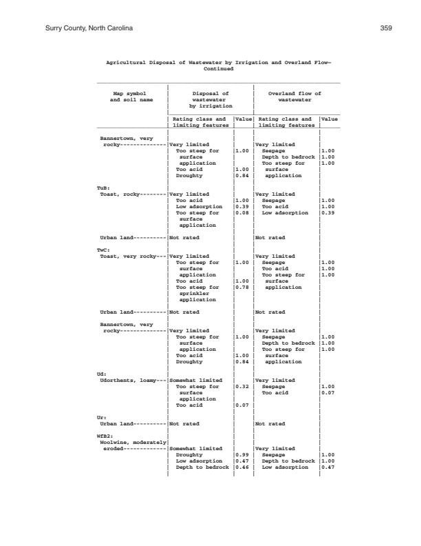
Surry County, North Carolina
359
Agricultural Disposal of Wastewater by Irrigation and Overland Flow--Continued
|
Map symbol
and soil name |
Disposal of
wastewater by irrigation |
Overland flow of
wastewater |
||
|---|---|---|---|---|
|
Rating class and
limiting features |
Value |
Rating class and
limiting features |
Value | |
|
Bannertown, very
rocky |
Very limited
Too steep for surface application Too acid Droughty |
1.00
1.00 0.84 |
Very limited
Seepage Depth to bedrock Too steep for surface application |
1.00
1.00 1.00 1.00 |
|
TuB:
Toast, rocky |
Very limited
Too acid Low adsorption Too steep for surface application |
1.00
0.39 0.08 |
Very limited
Seepage Too acid Low adsorption |
1.00
1.00 0.39 |
| Urban land | Not rated | Not rated | ||
|
TuC:
Toast, very rocky |
Very limited
Too steep for surface application Too acid Too steep for sprinkler application |
1.00
1.00 0.78 |
Very limited
Seepage Too acid Too steep for surface application |
1.00
1.00 1.00 |
| Urban land | Not rated | Not rated | ||
|
Bannertown, very
rocky |
Very limited
Too steep for surface application Too acid Droughty |
1.00
1.00 0.84 |
Very limited
Seepage Depth to bedrock Too steep for surface application |
1.00
1.00 1.00 1.00 |
|
Ud:
Udorthents, loamy |
Somewhat limited
Too steep for surface application Too acid |
0.32
0.07 |
Very limited
Seepage Too acid |
1.00
0.07 |
|
Ur:
Urban land |
Not rated | Not rated | ||
|
WFB2:
Woolwine, moderately eroded |
Somewhat limited
Droughty Low adsorption Depth to bedrock |
0.99
0.47 0.46 |
Very limited
Seepage Depth to bedrock Low adsorption |
1.00
1.00 1.00 0.47 |